nCa Report
Afghanistan is rapidly building an enormous canal to draw water from the Amudarya River. This has the potential to affect the water availability situation to Uzbekistan and Turkmenistan.
The Qosh Tepa Canal, named after the Qosh Tepa district in the Jawzjan province, will be 285km in length and 100 meters in width. It will help irrigate 550000 hectares of land (1.35 million acre, or 5500 square kilometers).
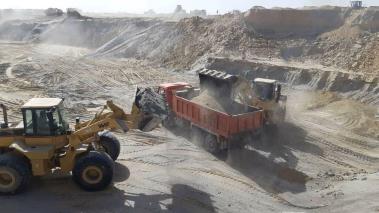
The Taliban sources told the Afghan media that at present some 5500 people are working simultaneously at about 120 locations to speed up the work. More than 3300 units of machinery are in use. More than 200 local companies are working as sub-contractors under the supervision of the Afghanistan National Development Company.
The Taliban are doing the first phase of the project, which is 100km in length, from their own revenues. The cost of the first phase is about USD 91 million.
For the subsequent two phases, they will generate funds from the selling of mines, particularly the Dar-e-Souph Mine.
The canal will have the capacity to carry 650 cusec (cubic meters per second) of water, feeding the lands in the Balkh, Jawzjan, and Faryab provinces. Of these, Jawzjan and Faryab provinces border with Turkmenistan.
More than half the work on the first phase has been completed and this 100km phase will be ready by June 2023, some two months ahead of the schedule.
The Economist reports that the project is not new. Plans for a canal in north Afghanistan had been discussed for decades; feasibility studies were carried out under its former American-backed government. Even so, the Taliban’s progress looks impressive. Satellite imagery supplied by Planet Labs, pbc, an American firm, reveals that over 100km of canal has been excavated in the past 10 months.
* * *
Amudarya River
There is a useful FAO report titled ‘THE AFGHAN PART OF AMU DARYA BASIN – Impact of Irrigation in Northern Afghanistan on Water Use in the Amu Darya Basin.’
It was compiled by Walter Klemm, Sr Land & Water Development Engineer, Investment Centre Division / FAO Rome, and Sayed Sharif Shobair, Chief Engineer and Coordinator of the Emergency Irrigation Rehabilitation Project of the Ministry of Energy and Water of Afghanistan, FAO Kabul.
The complete report can be found at this link:
https://unece.org/fileadmin/DAM/SPECA/documents/ecf/2010/FAO_report_e.pdf
Here are some relevant parts of the report:
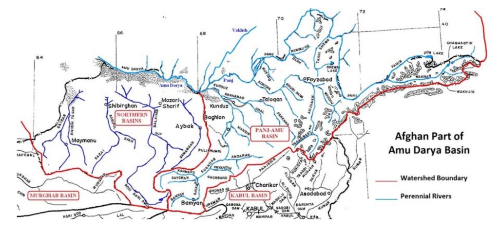
The Amu Darya is formed by three major source rivers: the Panj1 originating in Afghanistan (Pamir and Wakhan rivers), the Murghab River also originating in Afghanistan and flowing into the Lake Sarez, then being called Bartang River, and the Vakhsh originating in Kyrgizstan (Kyzylsu River) as well as in Tajikistan (Muksu River).
On its way to the Aral Depression, only below the confluence of Panj and Vakhsh, the river is now called Amu Darya which is joint on its right bank by a few more tributary rivers (Yaksu and Karnifaghan in Tajikistan, and Surkhandarya in Uzbekistan), and on its left bank by Kokcha and Kunduz river in Afghanistan. Two particularities should not go unnoted: The Zarafshan River, originating in Tajikistan and supplying with water the well known cities of Samarkand and Bokhara, does not join the Amu Darya anymore, thus it became another ’blind’ river, this time on the Uzbek side of Amu Darya.
By far the main single water user of the Amu Darya is the Karakum Canal, beginning at Turkmenian territory on the Western Afghan border and diverting a varying water volume of 12,000 to 22,000 million m³ per year to Turkmenistan. In order to have an idea about the flow capacity of Amu Darya from its origin on Afghan soil (Pamir and Wakhan rivers), the following observations are presented:
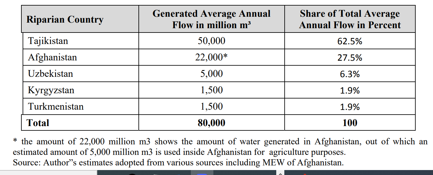
Average annual flow of Amu Darya and its tributaries is estimated according to various differing sources (depending on authors, countries, and time series used). An attempt to sub-divide the mean annual flow of the Amu Darya by riparian country produces the following:
In addition to this FAO report, useful information is also available at the website of the Interstate Commission for Water Coordination of Central Asia.
The relevant page there is ‘Basin Water Organization “Amudarya”’
[We recommend going through the contents of this website for deeper knowledge of the issue.]
Some worthwhile bits of information are copies here:
Amudarya River basin with total area 1017.8 thousands km 2 is located on territory of closed, isolated from oceans Aral Sea region without inflow.
Amudarya River basin covers totally territory of Turkmenistan and part of Tajikistan and Uzbekistan, Kyrgyzstan and Afghanistan.
Amudarya is the largest river in catchment area and water availability in Central Asia and is formed by Pyandj and Vakhsh rivers conjunction. Its total length from Pyandj River head to Aral Sea is 2574 km, from conjunction place 1415 km.
Pyandj River almost along all length passes border between Tajikistan and Afghanistan.
Amudarya River receives tributaries only within the first 180 km. Within 12 km from Pyandj and Vakhsh conjunction place Kunduz River (Afganistan) inflows from the left, within 38 km from the right Kafirnigan River, within 137 km Surkhandarya River, within 180 km Sherabad River.
Amudarya River basin is the largest in area and water availability in this region.
Another source on this subject is the research paper authored by Ikramuddin Kamil. It was published by the Chinese Journal of Environmental Law on 08 July 2021. The title of the paper is: ‘Afghanistan, the Amu Darya Basin and Regional Treaties’
It can be found here:
https://brill.com/view/journals/cjel/5/1/article-p37_3.xml?ebody=figures
* * *
The media house Turkmen Portal reported on 23 November 2020 that Turkmenistan and Afghanistan had reached agreement on the sharing of the trans-border water resources including the Amudarya River.
The Turkmen Portal story is available at this link:
It is also being reproduced in full here:
Afghanistan and Turkmenistan have agreed to share trans-border water resources
23 November 2020
Interaction between the relevant departments of the two countries on the coordinated use of Amu Darya and Murgab and Tejen rivers was discussed at the 4th meeting of the Coordination Commission on water management issues between Turkmenistan and the Islamic Republic of Afghanistan, which was held in the State water management Committee online.
The Afghan delegation at the talks was led by the Deputy Minister of water resources of the IRA for technical issues and the national water regulation authority, Ahmad Wais Basiri. Representatives of the State Committee of water management and the state border service represent the Turkmen side.
The Amu Darya, Murgab, and Tejen rivers, which are trans-border in Central Asia, are the main sources of water resources for agriculture and industry, electricity production, and drinking water supply. In this regard, the participants of the meeting called for the joint use of transboundary water resources in accordance with the provisions of international law and mutual consideration of the interests of the parties and in the framework of further strengthening and development of cooperation between Turkmenistan and the Islamic Republic of Afghanistan.
Following the meeting, the relevant Protocol was signed, the “Neutral Turkmenistan” newspaper reports today. /// nCa, 20 February 2023


