nCa Report
IGRAC (International Groundwater Resources Assessment Centre) is based in the Netherlands.
Since 2014, IGRAC has provided various inputs to the SDGs process, including position papers and articles contributing to the indicators of the targets 6.3.2 (water quality), 6.4.2 (water stress), 6.5.2 (transboundary waters) and 6.6.1 (ecosystems).
In 2018, the WWAP (World Water Assessment Programme, UNESCO) compiled the SDG6 Synthesis Report on Water and Sanitation 2018 and the Baseline monitoring reports for most of the SDG6 targets were drafted.
IGRAC participated in the technical meeting on indicator 6.5.2, held in Budapest in 2018. Additionally, IGRAC supported the IAH participation at the UN meeting on SDGs, in Vienna. On behalf of the groundwater community the IAH (International Association of Hydrogeologists) president made an intervention about necessity of introducing a groundwater indicator in the SDG monitoring process. For the training in Thailand, IGRAC prepared a dedicated presentation on Groundwater Governance and SDGs. In December, IGRAC provided an intervention on contribution of groundwater to environmental flow in the SDG6.4.2.
UN Water
https://www.unwater.org/about-un-water/members-and-partners/international-groundwater-resources-assessment-centre-igrac
IGRAC (International Groundwater Resources Assessment Centre) facilitates and promotes international sharing of information and knowledge required for sustainable groundwater resources development and management worldwide. Since 2003, IGRAC provides an independent content and process support, focusing particularly on transboundary aquifer assessment and groundwater monitoring. Read more about IGRAC mission and objectives and organisation at the following pages.
IGRAC
https://www.un-igrac.org/who-we-are
IGRAC’s mission is to contribute to world-wide availability of relevant information and knowledge on the groundwater resources of the world, with particular emphasis on developing countries, in order to support sustainable utilisation and management of the groundwater resources, to promote the role of groundwater in integrated water resources planning and elucidate the impact of groundwater on the ecosystems of the Earth.
Under the general objective of “promoting sustainable groundwater resources utilisation and management by means of global exchange of knowledge”, IGRAC is developing a global information system, conducting groundwater assessment at transboundary and global level, assisting in better monitoring of state of groundwater resources and supporting informed knowledge management and governance.
IGRAC is UNESCO Global Groundwater Centre, it also works under the auspices of WMO (World Meteorological Organization), it is a corporate IAH (International Association of Hydrogeologists) partner and it is financially supported by the Government of the Netherlands. The office of IGRAC is located in the Netherlands. It is also an in-house partner of the IHE Delft Institute for Water Education.
* * *
IGRAC website says that Central Asia is a very interesting region in terms of groundwater, because its dependence on groundwater as a source of drinking water and irrigation has been increasing for years. One of the main reasons for this increase is the drying of the Aral Sea, which is shared by Kazakhstan and Uzbekistan and of which its drainage basin also encompasses parts of Tajikistan, Turkmenistan, Kyrgyzstan, Kazakhstan, Afghanistan and Pakistan.
IGRAC – Central Asia
https://www.un-igrac.org/regions/central-asia
The Aral Sea was once the world´s fourth largest lake, but over the past fifty years it has shrunk by 90 percent. ‘It is clearly one of the worst environmental disasters of the world´, was what U.N. Secretary-General Ban Ki-moon said after visiting the area. In 1997, the shrunk Aral Sea split into a southern Uzbek part and a northern Kazakh part. In both sections, there have been several initiatives to revitalise the Aral Sea.
One of IGRAC’s main activities in Central Asia has been groundwater assessment in the Pretashkent Aquifer, shared by Kazakhstan and Uzbekistan. This case study was one of the three in-depth assessments that have been conducted as part of the Groundwater Resources Governance in Transboundary Aquifers (GGRETA). In addition, IGRAC has recently organised the Aral Sea Roundtable to discuss the main challenges and solutions in the region.
Pretashkent Aquifer
In the first phase of GGRETA project, the Pretashkent Aquifer pilot study – a synthesis and interpretation of existing information – was carried out only in Kazakhstan. Therefore, a description below merely addresses the Kazakh part of the aquifer. In the second project phase, Uzbek scientists joined their Kazakh colleagues in common effort to assess and model groundwater resources of the Pretashkent Aquifer. The first steps in that directions were made at the expert meeting in Tashkent, held in May 2018.
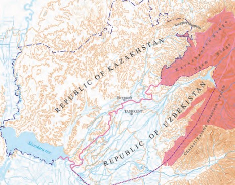
The Pretashkent Transboundary Aquifer is located at considerable depth under a relatively flat area of piedmont and alluvial plains bordered by the Shardara reservoir and Syrdarya river in the South and West, and by spurs of the Tian Shian and Chatkalo-Kuramin mountain systems to the North-East and East. This area includes three administrative districts of southern Kazakhstan and thirteen districts in the adjoining part of Uzbekistan (including the capital Tashkent). The aquifer delineation is based on geological formation boundaries and the location of the aquifer’s main discharge zone. The Pretashkent Transboundary Aquifer is an example of medium-sized deeply buried artesian aquifers with negligible recent recharge.
IGRAC – Pretashkent Aquifer
https://www.un-igrac.org/case-study/pretashkent-aquifer
The area underlain by the Pretashkent Transboundary Aquifer measures approximately 17,000 km2, of which 10,840 km2 in Kazakhstan. The elevation of the area ranges from 214 m above mean sea level at its Western border to slightly over 1,000 m in the East. The Eastward bordering mountain ridges, outside the PTBA area, rise to more than 3,600 m. The area has a continental dry climate, with hot summers (mean July temperature 25 to 30 °C) and a relatively warm winter (mean January temperature -4 to 0 °C). Precipitation falls mainly during the period November-May – during winter mostly in solid form, during other seasons in the form of rains – and varies from year to year between 200–350 mm/year in the South-West (Shardara) to 350–360 mm/year more North-Eastward (Kazygurt), and to even some 20% more at the Eastern border. The area’s climate is characterised by a precipitation deficit.
Some 92% of the population of 5.5 million lives in Uzbekistan, thus the population density in the Uzbekistani sector (which includes the Tashkent capital territory) is more than one order of magnitude higher than in the Kazakhstani sector. This difference in population density is reflected in the dominant categories of economic activities: mainly agriculture and food industries in the Kazakhstani sector, versus engineering, chemical industries, metallurgy and agriculture in the Uzbekistani sector.
 Permanent rivers in the area are the Syrdarya river (along the area’s Western border) and the Keles river (running parallel and close to the boundary with Uzbekistan). Both are meanly fed by snow-melt and their mean annual discharge volumes are 37 and 0.96 km3, respectively. Other surface water bodies in the area include two ephemeral rivers, the transboundary Keles irrigation canal (flow of 8 m3/s in the Saryagash district) and the Shardara reservoir (900 km2 in size). All these surface water sources are used for irrigation and watering of pastures. The Shardara reservoir is in addition a wetland of national significance, famous for various endangered and rare species of swimming birds. Groundwater is present in a complex sequence of superimposed geological formations. Groundwater is fresh in some of these formations, but in others it is brackish. Shallow groundwater tables (less than 3 m deep) are found mainly near the rivers and along the Shardara reservoir.
Almost 99% of all water withdrawn is for agriculture (mainly for irrigation) and most of the remaining 1% is for domestic and public water supply. Bottling and other industrial uses account for less than 0.06%. Representing only 5.1% of all water withdrawn, groundwater seems at first glance an insignificant source of water, but this is not the case, since only groundwater meets drinking water quality standards. Therefore, the population depends for drinking water almost entirely on groundwater. Most groundwater used for domestic purposes (90%) and all water used for bottling comes from the Pretashkent Transboundary aquifer, while groundwater used for agricultural purposes is withdrawn from overlying nontransboundary aquifers.
Water demands and water use are likely to increase in the future, in response to population growth (mean annual growth rate was 2.6% over the period 2005–2014), to economic development (although the area of arable lands tends to decrease) and perhaps also to climate change.
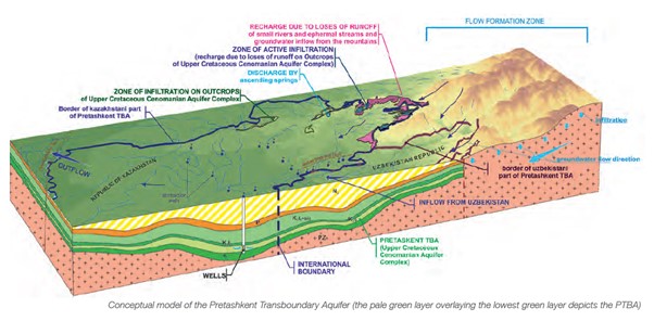
The area considered forms part of a depressed geological structure where a more than 2,000 m thick sequence of sediments has accumulated during the last 140 million years. These sediments – sandstones, sands, conglomerates, gritstones, gravels, boulders, silts, clays, argillites and limestones – are arranged in sub-horizontal layers (slightly tilted and folded) that produce an alternation of permeable layers (aquifer beds) and layers that offer resistance to groundwater flow (aquitards).
The upper aquifer beds (of which the uppermost one has a free water-table) tend to be non-transboundary and several of them contain brackish water. The so-called Upper-Cretaceous Cenomanian Aquifer Complex, in the lower part of the sedimentary sequence (see the conceptual model presented below as a block diagram), however, is continuous in the region and transboundary, and is called the Pretashkent Transboundary Aquifer (PTBA). It is the most important aquifer in the area, contains fresh water and it is in artesian conditions, characterised by flowing wells. Although the PTBA is located at great depth (mean depth 1,064 m), there is substantial information available on its hydrogeological and hydraulic properties.
Due to its predominantly great depth and the hydraulic protection by an overlying regional aquitard, the PTBA is not vulnerable to pollution. Climate change will not have a significant direct impact (since the aquifer resources are virtually nonrenewable), but there may be an indirect impact by potentially increasing water demands in the area.
The main problem offered by the PTBA is the unavoidable depletion of groundwater storage in response to groundwater withdrawal. After a certain period of exploitation, currently flowing wells will be no longer be artesian and will need to be pumped; while on the long run, groundwater levels will drop below technically or economically maximum exploitable depths. Reduction of the groundwater pressures will quickly expand laterally, also across the international border.
Potential degradation of groundwater quality is another major concern. As far as the PTBA is concerned, only its recharge zones – very limited in size – are exposed to pollution. Nevertheless, progressive drops of water levels in the TBA may trigger invasion of brackish and saline groundwater from overlying strata. Pollution of shallow local aquifers, finally, may result in substitution of their exploitation by withdrawals from the TBA. /// nCa, 25 April 2024
