A stunning nighttime photograph taken from the International Space Station reveals Ashgabat, Turkmenistan’s capital city, as a brilliant cluster of lights nestled between the dark silhouettes of the Kopetdag mountains and the vast Garagum desert. This remarkable image, captured on September 16, 2024, offers a unique perspective of the Central Asian metropolis.
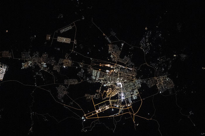
The photograph highlights Ashgabat’s strategic location and urban development. At the city’s heart, the international airport and M37 highway shine prominently against the darkness, serving as vital transportation arteries. Thin, yellow-hued lines in the southern sector of the city are brightly lit roadways serving neighborhoods close to the mountains.
Surrounded by desert setting and located in oasis, Ashgabat maintains a thriving agricultural sector thanks to water resources from the neighboring mountains. Dark patches visible within the city limits represent agricultural fields and water reservoirs, where farmers cultivate wheat, cotton, and rice, demonstrating remarkable adaptation to the arid climate.
The M37 highway, visible as a bright line, plays a crucial role in regional connectivity. This major corridor spans an impressive 1,500 kilometers, linking Uzbekistan to Turkmenistan’s Caspian Sea coast and connecting several towns along the Kopetdag mountain range.
The photograph was taken by an Expedition 71 crew member using a Nikon Z9 digital camera using a focal length of 200 millimeters, providing scientists and the public with valuable insights into urban development and human adaptation to challenging geographical conditions. This image is part of NASA’s broader effort to document Earth’s changing landscape through the ISS National Lab program, making such observations freely available to researchers and the general public. ///nCa, 24 February 2025 (photo credit – Earth Observatory, NASA’s online publishing outlet)