nCa Report
In the first part of this series, we quoted from a research study about TBAs (Transboundary Aquifers) in Central Asia.
The term Transboundary in the context of aquifers is not very old – it was first used in 2017.
When an aquifer is transboundary i.e. shared by two or more countries, its physical features are trumped by the corresponding geostrategic conditions. For example, if the recharging of the aquifer is taking place through natural sources in one country but the groundwater is being drawn by another country, it becomes a source of contention. There can be many other variables.
Nevertheless, in this series we are primarily concerned about recharging the aquifers so that they can be maintained as a sustainable source of groundwater. This holds good for all aquifers, whether they are transboundary or located entirely under the soil of a single country.
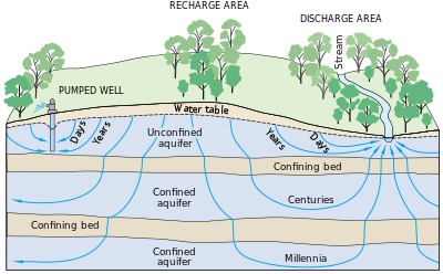
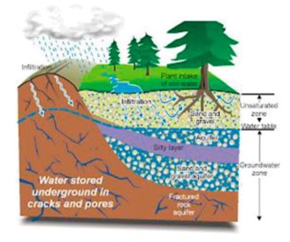
The physical characteristics of an aquifer vary greatly. The aquifer, as an underground layer of water-bearing material, can be permeable or fractured rock, or composed of unconsolidated material such as gravel, sand, or silt.
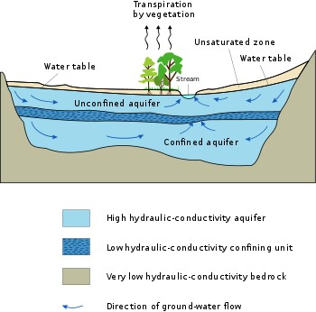
Aquifers can be saturated or unsaturated; confined or unconfined; isotropic or anisotropic; porous, karst, or fractured; etc.
Providing greater details about the characteristics of aquifers is beyond the scope of this report.
Aquifers or pockets of groundwater can occur at any depth from just below the ground to a depth more than 9000 meters.
Many desert areas have limestone hills or mountains within them or close to them that can be exploited as groundwater resources.
Since an aquifer is a pocket of water or water-bearing material, it has a finite volume of water, which depletes during exploitation. To maintain its sustainability, it must be recharged, naturally or artificially. — when water from the ground moves below the ground and into the pocket formed by the aquifer, it is called the recharging of the aquifer.
There is plenty of research and technical material on recharging of the aquifers. Here, we will refer to just one paper, authored by Muthuminal and Mohana Priya. It is titled, ‘An Overview on Techniques Involved in Recharging Ground Water and Its Impacts.’
This paper forms a chapter in the collection of studies with the title, ‘Irrigation and Drainage.’ In the book form, it was edited by Muhammad Sultan and Fiaz Ahmad. The date of publication of the web version is 17 June 2022.
The Muthuminal and Priya paper is available at this link:
https://www.intechopen.com/chapters/82293
The remaining portion of this part of our report quotes extensively from the Muthuminal & Priya paper:
The movement of water from the surface of the earth into the sub surface areas are said to be as a hydrologic process which helps in improving the water table at the ground level. This process of water movement towards downward direction is said to be as Groundwater recharge or deep drainage or deep percolation.
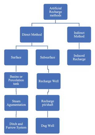
Ground water recharge could be achieved either by natural method or by artificial method, which involves anthropogenic processes.
Some of the manmade process are artificial recharge methods which are carried out through rain water harvesting where the rain water is channeled into the subsurface zone by bore holes.
The world is surrounded by 99% of seawater, and only one percentage covers the water, which could be adopted as potable water. This 1% of potable water covers the fresh water that is available at the streams and the ground water which is stored under the aquifers. Among which the 40% of ground water is currently utilized for the world’s irrigation purpose alone, as it provides about 13% of total food production and also 44% of irrigated food production globally.
Though the food production and agricultural crop yield has significantly increased, in certain parts of the world the depletion of ground water has been occurring, leading to replenishment levels.
An estimated amount of 14 to 17 percent of food produced with groundwater relies on unsustainable mining of groundwater resources globally. Regionally, the reliance on depleting groundwater sources for food production is greatest in South Asia, the OECD countries, East Asia, and the Near East and North Africa (MENA), where 15 percent, 16 percent, 21 percent, and 25 percent of total crop production from groundwater, respectively, is unsustainable.
In order to maintain the sustainability, the process of ground water recharge is adopted at which the recharge rates are usually difficult to measure. The difficulty in quantifying the rate of ground water recharge has become a tedious process because, it is in need to measure the related processes such as transpiration, evaporation and infiltration for achieving balance in the environment.
As far as the recharging of an aquifer is concerned, the Natural methods involve precipitation on soil, which enters into the soil. The other form of natural recharge occurs when there is leakage of water from lakes, ponds, streams etc.
The Artificial method is more efficient in comparison with natural method, the amount of water consumed per capita is decreasing day by day and to increase the ground water recharge we need artificial method. This artificial method involves various techniques.
Artificial recharge
Artificial recharge
Basins or percolation tank
A percolation tank is a anthropogenic method which consist of highly permeable land in its reservoir, which allows the excess runoff water to percolate and it will increase the storage of ground water.
The objective of percolation tank is ground water recharge; it allows leakage under bed’s seat. The majority of percolation tanks are earthen dams, with masonry structures serving only as spillways.
Ditch and furrow system
Shallow, flat-bottomed, and closely spaced ditches or furrows provide maximal water contact area for recharge water from the source stream or canal in locations with variable topography. This technique is less sensitive to silting and preparation of soil is very less.
Lateral ditch pattern
The surface runoff water is streamed into a feeder canal/ditch, from which smaller ditches at right angles are formed. The flow rate from feeder cannal to ditiches is monitored by Gate valves. The factors such as uniform velocity, maximum wetted surface and furrow depth are determined by topography. A return canal transports the excess water, as well as any remaining sediment, back to the main stream.
Dendritic (tree-like) pattern
The water is streamed into the main canal. This pattern is continued until all the water are infiltrated into the ground through smaller ditches which are connected with main canal in tree like pattern.
Contour pattern
Ditches are excavated in accord with the area’s ground surface outline. The ditches are designed in such way to move front and back to navigate the spread area multiple times and switchback if ditch get close to the stream. The ditch joins the main stream to downstream at its lowest point, returning extra water to it.
Stream augmentation
The most important source of ground water reservoir is leakage that occurs from natural streams or rivers. When the total available water supply in the stream/river exceeds the rate of infiltration, the excess is lost as runoff. The infiltration can be increased by installing check bunds where runoff water can be stopped when the total available water exceeds the infiltration range.
* * *
For anyone interested in more details, it would be useful to download and read the Muthuminal & Priya paper.
There is plenty of material from other authors, available at open sources. /// nCa, 24 April 2024


